July 5, 2024: From tree line near 8,000 feet, looking up at the Clear Creek route on a guided climb of Mt Shasta. The route follows the snowfield directly in the center of the photo. Above the snowfield, there are several options to follow well-developed trails through the scree. However, we climbed on the thin ribbon of snow with crampons for more direct and efficient travel.
The last week in June marked the transition to summer as a significant heat wave arrived to northern California, and with it increasing natural rockfall hazard on Mt Shasta’s Avalanche Gulch route. Rock fall is one of the primary hazards on the Avalanche Gulch route, and it increases dramatically during the marked transition from spring to summer. As the climbing season slows down, in the interest of safety, we have made the seasonal switch away from the Avalanche Gulch route to the Hotlum/Bolam Ridge and Clear Creek routes. Our 2025 trip dates will be posted and available for booking very soon!
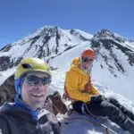
Over the past week, we guided two trips on Mt Shasta’s Clear Creek route from July 5 to July 10. The Clear Creek route is in great shape right now, but the snow that makes travel so efficient, is melting quickly!
The Clear Creek trailhead begins at 6600 feet in a beautiful old growth of Red Fir. The trail is about 3.3 miles in distance and 2000 feet of elevation gain to the recommended base camp at the spring that feeds Clear Creek proper. There is no need to filter this pristine water source, but those that camp here should take care to preserve it. On both trips, I found camps near the spring polluted with trash from other groups. I packed out the litter. Mt Shasta is a federally designated wilderness area and it is illegal to leave trash behind. It’s everyone’s responsibility to arrive prepared and Leave No Trace. On the first day of both our most recent Clear Creek summit trips, we established a base camp near the spring under the shade of wind-sculpted White Bark Pines. These trees offer nice refuge from the sweltering summer sun. Also, with the warm temperatures comes the mosquitoes and black flies that are beginning to thrive in the hot afternoon sun.
On the second day of both trips, we departed from our base camp at 8,600 feet at 2am. We quickly joined the first snow field at 9,000 feet where we used the snow to our advantage. We found good snow coverage from 9,000 feet up to about 11,700 feet following intermittent snow fields and a ribbon of snow that extends into the upper reaches of the route’s upper screen fan. These ribbons of snow are common on Clear Creek and are an excellent way of gaining elevation quickly, limiting your time on scree, and adding some variety to the route.
From the top of the snow ribbon, we removed our boot crampons from where the continuous snow terminates. We traveled up and to the right (north), boulder bashing our way through loose rock until intersecting the closest trail of tighter steep switchbacks. These switchbacks lead through the scree and allow for relatively easy passage up to UFO Rock – make sure you find them!
Record breaking high temperatures and wildfire smoke from the Shelly Fire in the Marble Mountains are moving in as the warm and relentless California summer progresses. The best time to climb Mt Shasta (May and June) has come and gone as wildfire season settles in.
I will be posting our 2025 trip dates very soon! If you’d like to book a trip with me as your guide for a personalized Mt Shasta experience on a summit climb or ski descent, please don’t hesitate to send me an email at [email protected].
Cheers,
Shane
- Consider downloading a mapping app to your mobile phone like Gaia or CalTopo. Pre-download the map layers from a wifi connection at home. Google Satellite imagery and a mapping app can help with route finding on the Clear Creek route once the route is devoid of snow. The trails through scree on the upper part of the route show up remarkably well on satellite imagery.
- UFO Rock is sometimes also called Mushroom Rock. UFO Rock sits at 12,900 feet and is a good decision making point.
- The north side of UFO Rock is a great shady place to rest, especially on the descent. During summer climbing attempts, temporarily caching water here for the descent could be a worthwhile consideration.
- There are two sets of switchbacks to get to UFO Rock. On the climb up, I typically use the tighter steeper switchbacks which are further south. On the descent, I prefer to use the longer and wider switchbacks which are further north on the screen fan. This way also offers nice views of the Wintun and Watkins Glaciers.
- Although the wider switchbacks are slightly longer in distance, they allow for a more gentle angle of descent. Another advantage of taking the wider switchbacks is, on a hot summer day, at approximately 12,000 feet there is a large boulder (41.40213, -122.18266) which offers shade and some relief from the intense summer heat.
- Above UFO Rock, go straight up to gain the summit plateau. Keep the solid red rock (basalt) on your left and use it as a handrail to work your way up through the loose rock. Be conscious of and considerate of other climbers below you. Tread lightly and yell “ROCK!” if you observe loose rock tumbling downhill. Wear a helmet.
July 7, 2024: This photo was taken from our base camp at approximately 8,600 feet on the Clear Creek route near the spring. The photo is looking up at the heavily sun-cupped intermittent snowfields that give access to the route’s upper screen fan. The snow won’t last long, but currently, these snowfields allow for up to 1000 feet of glissading on the descent. Always be extremely cautious when considering the decision to glissade. Always use proper technique. Asses the runout below you and the quality of the snow. The snow should be well-softened in the afternoon sun. If in doubt, walk down. Glissading should only be used as a means of efficient travel – not for thrill seeking, although it can be fun.
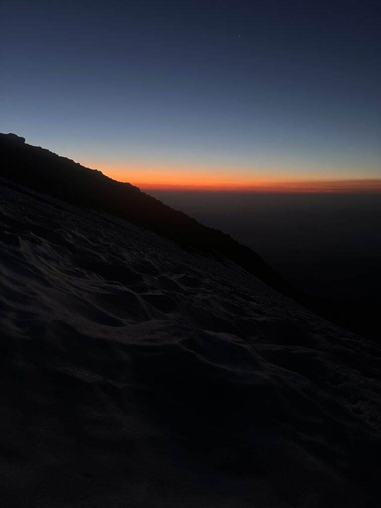
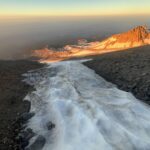
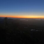
July 9, 2024: Sunrise from the Clear Creek route while guiding a summit climb of Mt Shasta. The brilliant orange hue is due to the sun filtering through a smoke inversion layer from the Shelly Fire in the Marble Mountains to the west.
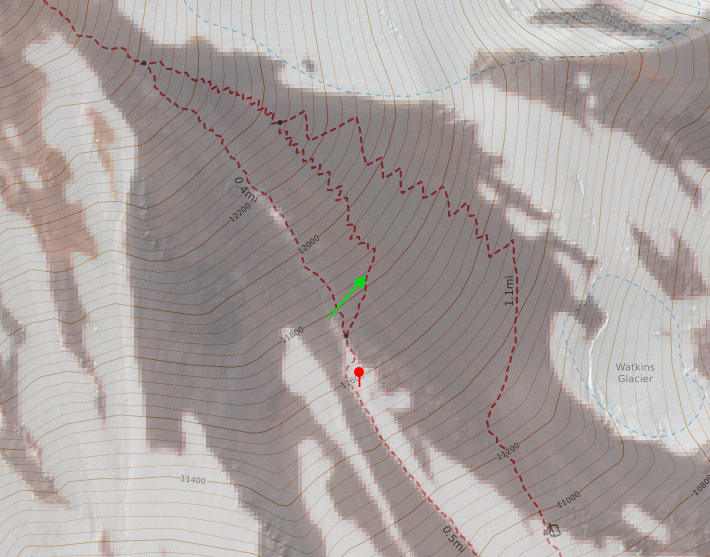
Recent satellite imagery (July 5, 2024) showing the ribbon of snow we used to gain elevation and limit our time traveling on scree. The satellite imagery is overlayed with the topographic map showing the Clear Creek route lines. The red marker is where the photo below is taken looking up from 11,500 feet at the ribbon of snow that we climbed. The green line is where we left the snow and made the traverse to re-gain the well-developed trail in the scree to the tighter zig zags (left). I use the wider zig zags (right) for the descent.
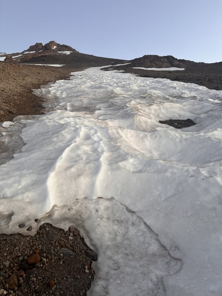
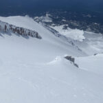
July 9, 2024: This is the location of the red marker in the screenshot of the map posted above. The photo is taken at 11,500 feet on the Clear Creek route on Mt Shasta, looking up at the ribbon of snow that we opted to climb. The well-developed trails in the scree are out of the frame to the right.
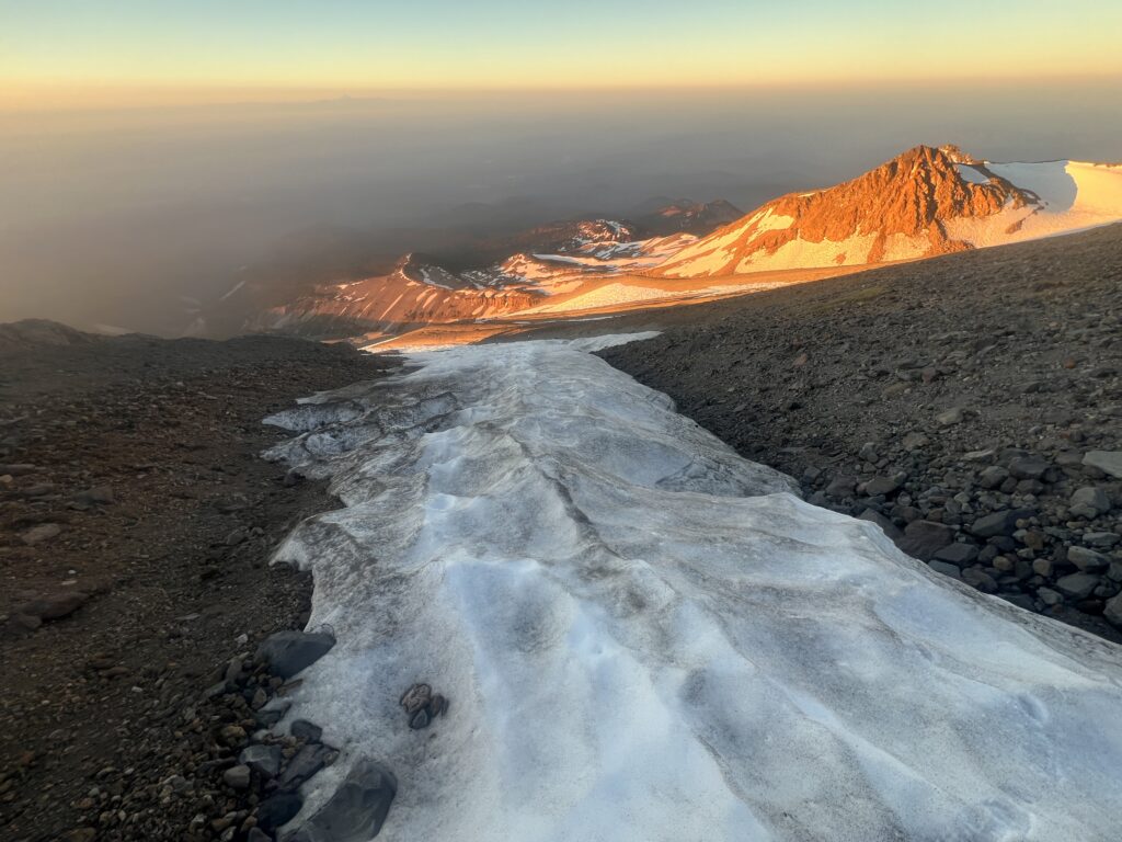
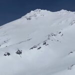
July 9, 2024: Looking down the snow ribbon at sunrise near where the snow terminates at 11,700 feet. We removed our crampons here. A smoke inversion layer from the Shelly Fire can be seen in the valleys below.
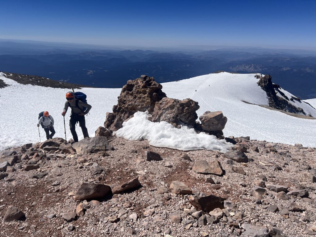
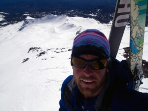
July 5, 2024: Approaching the summit cone from the Clear Creek route. The Clear Creek route gains the summit plateau from the left of the photo. The well-worn path crossing the snow on the summit plateau to the right is where the south side routes top out Misery Hill and gain the plateau (Avalanche Gulch route).
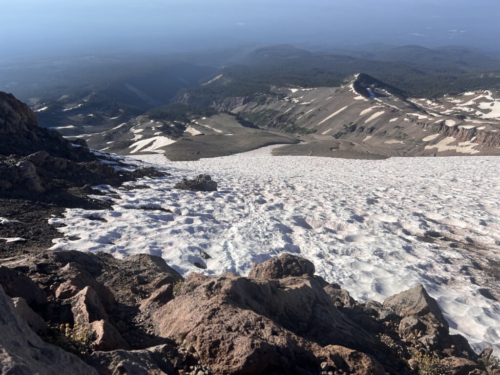
July 9, 2024: Looking down the Clear Creek route at 10,900 feet on our descent. This is where the current glissade track begins. Above this, the snow surface is too variable from sun cups to be effective for glissading.